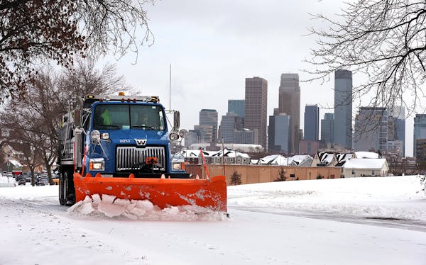
Minnesotans shoveled snow and scraped ice from their cars Saturday after heavy snow, freezing drizzle and blustery winds pummeled Minnesota overnight and into the morning.
A winter storm warning remains in effect for much of the state until 6 p.m. Saturday, while a blizzard warning still covers the west, including Fergus Falls, Morris, Willmar, Marshall and Worthington. The State Patrol was still advising no travel for many routes in south-central and southwestern Minnesota, where roads are snow-covered and visibility was near zero in some areas.
Minneapolis and St. Paul declared snow emergencies starting tonight at 9. (See details at hyperlinks.)
By 6 a.m. Saturday, 4.9 inches of snow had fallen at the Minneapolis-St. Paul International Airport, with 4.6 inches at the National Weather Service's regional office in Chanhassen.
Late Friday, the forecast for snowfall amounts was dialed down when a "dry slot" 12,000 feet aloft caused snow to transition to freezing rain, NWS meteorologist Mike Griesinger said. The sloppy mix was expected to turn back to snow after midnight, but the hours of weightier precipitation will bring down snow depth, he said.
To the north and west, snowfall totals were still considerable, and high winds ruled the night.
State Patrol Col. Matt Langer urged people to delay or cancel travel and to stay home if possible. Many did, but even in relatively light traffic, troopers were called to respond to many crashes on icy roads.
From 5 a.m. to 9:30 p.m. Friday, the patrol responded to 171 crashes statewide, 20 of them with injuries; 166 spinouts or vehicles off the road; and six jackknifed semitrailer trucks. From 9 p.m. Friday to 6 a.m. Saturday, there were an additional 47 crashes, six with injuries, including a serious-injury crash in St. Paul, and 64 spinouts and vehicles off the road.
The initial forecast led many school districts to cancel classes Friday. Others opted for early dismissals.
All 800 of MnDOT's plows were tackling roads, and crews will be on the job until roads are clear, said spokeswoman Anne Meyer.
But, she warned, it will take time to get them all cleared off, and low temperatures will hinder the ability of chemicals to melt ice and snow left behind.
"The rate of snow will be hard for operators to keep up with, so that could cause compaction on the highways — causing more slick spots and longer time to clear roads to bare pavement," she said.
Even in the metro, crews were warning that it will be hard to keep roads clear until the system moves out of the area.
"Due to the large volume of precipitation, it may take more than one day to fully clear the snow," a statement from the Woodbury Public Works Department said.
After the storm moves out, the forecast calls for quiet and cold conditions to start the week.
Highs under mostly sunny skies will be in the single digits above zero on Sunday and Monday, rising into the teens on Tuesday and mid-20s on Wednesday.
Lows will be in the single digits below zero Sunday and Monday and moderating to above-zero lows by Tuesday.
Another storm may take aim at Minnesota next weekend. But it's too early to say how much snow it might bring.
Staff writers Pamela Miller and Tim Harlow, along with Henry Erlandson, contributed to this report. Erlandson is a Northwestern University student on assignment for the Star Tribune.

Want to share info with the Star Tribune? How to do it securely

'Safe recovery sites' would offer syringes, naloxone and more to people using drugs. The plan could be in peril.
New Minnesota GOP leaders seek peace with party's anti-establishment wing

Who is Republican Lisa Demuth, Minnesota's first House speaker of color?

