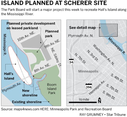
Workers will soon bring back a lost island in the Mississippi River in northeast Minneapolis, creating a new destination for paddlers and wildlife watchers near the Plymouth Avenue bridge.
Construction of the 3.3-acre site, which begins this month, will restore a channel between the mainland and what used to be Hall's Island, an area that Scherer Bros. filled in decades ago to expand its mill operations.
Crews will also expand the shoreline into the river and replace contaminants with clean fill and soil to build habitat for migrating birds and other animals. The Park Board will plant grass, trees and shrubs on the island in the spring.
"Having a natural habitat helps to keep the river clean, and by providing the island, we would now have a channel by which people can use and access the river in ways they can't today," Park Superintendent Jayne Miller said.
The $8 million project will also create a gravel beach on the mainland for launching kayaks and canoes.
The island will be off-limits to visitors until a second phase, when a boardwalk, two footbridges from the island to the mainland, and a third one to Boom Island Park are built. Future phases call for a park pavilion, gathering space and canoe and kayak storage and rental.
The project restores Hall's Island, which disappeared in the early 1960s after the lumber company filled in the eastern channel.
In 2010, the Park Board acquired the 11-acre Scherer site for $7.7 million. The agency has so far raised $6.7 million to re-create the island, including a $4.3 million grant from the Parks and Trails Legacy Fund.
The long-planned project has changed in response to concerns about potential damage to the river.
In 2012, the Minnesota Department of Natural Resources warned the Park Board that state rules prohibited adding materials to water to create uplands or islands.
Now it expects to issue a permit because the Park Board's redesigned plan focuses more on its environmental benefits, rather than recreation.
"They have refocused the project to try to create that habitat and minimize the human impact on the island," said DNR district hydrologist Kate Drewry.
A river within reach
Park Board Member Liz Wielinski, whose district includes Hall's Island, said they have designed the project to withstand flooding and other erosive forces.
She said the proposed design will also allow people to go down and touch the waters.
"Any time we're building new parks, particularly along the river, [they] are expensive," Wielinski said. "We have to make them to withstand the power of the river."
Chris Meyer, a candidate for the Park Board for that district, said he supports the project, and residents in his area are thrilled, but some worry about gentrification.
"It's a chance for us to get the same amenities that they have in the southern part of the city," Meyer said. But "as we get better amenities in some areas then that tends to drive up home prices nearby."
The Park Board is still mulling over becoming developers for a 3.5-acre portion of the Scherer land, called Parcel D, where they hope a private developer could build amenities, such as concession stands, that could help pay for upkeep of the park.
Earlier this year, the Park Board failed to draw proposals for the site.
"With development of the island, creating canoeing and kayak space, it might actually be an incentive for developers on that site," Miller said.
Faiza Mahamud • 612-673-4203

Want to share info with the Star Tribune? How to do it securely

'Safe recovery sites' would offer syringes, naloxone and more to people using drugs. The plan could be in peril.
New Minnesota GOP leaders seek peace with party's anti-establishment wing

Who is Republican Lisa Demuth, Minnesota's first House speaker of color?


