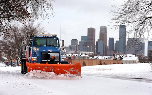
The metro area's first major snowfall of the season arrived Tuesday, triggering storm warnings, hampering commutes, delaying flights, closing schools and deploying plows to keep roads clear.
Heavy snow hit the Twin Cities, with Minneapolis-St. Paul International Airport measuring 8.4 inches at 6 p.m.
Similar snowfall was measured in Bloomington and the south metro, though Chanhassen saw 5.3 inches. The east metro also saw high totals, with Stillwater measuring 8 inches and North St. Paul about 7 inches.
Farther south, St. Peter and Mankato measured 8 and 7 inches, respectively. Northeast Minnesota saw significantly less, with 1 to 3 inches of snow in the Duluth area and 3 inches in Cloquet.
In southwest Minnesota, 2 inches fell on Luverne and 3.5 inches in Edgerton.
"It's a nice, plowable snow up to the boot laces in some places," said Kenny Blumenfeld, a Department of Natural Resources climatologist. "But it's not one of our famed blizzards."
Drivers were warned that travel would be difficult. "If you must travel, keep an extra flashlight, food and water in your vehicle in case of an emergency," the Weather Service advised.
Late Tuesday, westbound Interstate 694 reopened in Oakdale after a semitrailer truck jackknifed on a bridge over the Interstate.
Cities declaring snow emergencies include Minneapolis, St. Paul, Eden Prairie, Cambridge, Faribault, Brooklyn Park, Bloomington, Richfield and Osseo.
All runways at Minneapolis-St. Paul International Airport closed at 1:45 p.m. because snow was piling up too fast for aircraft to land safely, said Jeff Lea, spokesperson for the Metropolitan Airports Commission. Lea said the first runway was cleared and reopened around 4 p.m., and he expected a second runway to open within an hour.
"I've never had a shutdown of an airport like this while you're in the air, but nothing I can do about it," said Matt Witosky, 46, of Raleigh, N.C., who was on a business trip and had his flight diverted to Fargo instead of Minneapolis.
As of 6:30 p.m., 346 flights in and out of Minneapolis-St. Paul International Airport had been delayed and 128 flights canceled, according to the flight tracking website Flightaware.
Though significant, Tuesday's snowfall ranked in the middle of the pack for memorable November storms — and was right on schedule, Blumenfeld said.
"You are in late November so it can be a snowy time," he said.
But it was hardly a record-breaker. The daily snowfall record for Nov. 29 dates to 1991, the same year as the famed Halloween snowstorm. More than a foot of snow walloped the metro area, with an official reading of 12.6 inches at the airport, climatology office records show.
"That shut everything down," Blumenfeld said.
Still, the lengthy snowfall session Tuesday was enough for schools to close in parts of southern Minnesota, including in Blue Earth and Jackson counties. In the metro, districts including Richfield, North St. Paul, Wayzata and White Bear Lake sent some students home early.
After-school events were called off in Anoka Hennepin, Hopkins, Edina, Minneapolis, St. Paul and other districts, and school buses were expected to experience afternoon delays.
As of 2 p.m., Metro Transit reported that 56% of its buses were behind schedule, with an average delay of 11 minutes.
The Minnesota Department of Transportation sent out more than 200 plows area to push snow off metro roads, but with snow falling at an inch or more an hour midday, it was a challenge keeping roads clear, said MnDOT spokesperson Anne Meyer.
Roads by mid-morning were partly or completely snow-covered in the southern third of the state and from the Twin Cities to near Duluth, MnDOT said.
"People think if we pretreat the roads, we will be fine," Meyer said. "That is not true."
Nonetheless, plows were expected to be out all day and throughout the night to keep the roads clear, she said.
Between 10 a.m. and 4 p.m., the State Patrol responded to 169 crashes, 151 spinouts and 14 jackknifed semitrailer trucks across the state. None of the incidents resulted in serious injuries or deaths, tweeted Lt. Gordon Shank, public information officer with the patrol.
Behind the storm, winds will pick up and send the mercury falling into the 20s for highs on Wednesday, with lows in the single digits. Windchill values will be even lower, the Weather Service said.
But no temperature marks will fall as low as the record for tonight: -12 degrees, set in 1985.

Want to share info with the Star Tribune? How to do it securely

'Safe recovery sites' would offer syringes, naloxone and more to people using drugs. The plan could be in peril.
New Minnesota GOP leaders seek peace with party's anti-establishment wing

Who is Republican Lisa Demuth, Minnesota's first House speaker of color?


